Rivers and Creeks - "Clark Fork"
Clark Fork (River) Details
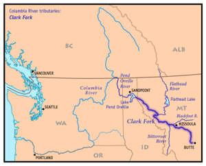
The "Clark Fork of the Columbia" was named after William Clark, and is a major tributary of the Columbia River.
The Clark Fork River has its headwaters in the Silver Bow (aka Highland) Mountains (less than 5 miles from the continental divide) and originates at the confluence of Silver Bow
and Warm Springs creeks near Anaconda Montana. The Upper Clark Fork flows northwest passing south of the Garnet Mountain Range. Approximately 5 (five) miles east of Missoula Montana the
Clark Fork receives the Blackfoot River. This confluence is mitigated by the reservoir behind the +100 year old Milltown Dam (which is currently slated for removal late 2007).
Northwest of Missoula, the Clark Fork runs through the Bitterroot Range (through the Lolo National Forest). The confluence of the Bitterroot into the Clark Fork occurs about 5.5 miles west of Missoula.
The Middle Clark Fork River starts after the Milltown Reservoir for approximately 115 miles (until the confluence of the Flathead River)
which runs from the north near Paradise Montana. The confluence of the Thompson River into the Lower Clark Fork (located near Thompson Falls) occurs from the west. In Noxon Montana
located along the northern end of the Bitterroot range (near the Idaho border) the river is constricted by the Noxon Rapids Dam which forms a 20 mile reservoir. This reservoir crosses into northern Idaho near the town of Cabinet.
Five (5) miles west of the Idaho-Montana border, the Clark Fork enters the eastern end of Lake Pend Oreille near the town of Clark Fork. The Pend Oreille River drains the lake into the Columbia River which flows to the Pacific Coast.
Clark Fork (River) History
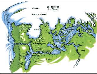 During the ice age the Clark Fork Valley was part of the the southern edge of the Cordilleran ice mass that covered the western portion of North America. The movement of the ice mass created an ice
dam on the river which as a result created Glacial Lake Missoula (at maximum height and extent exceeded 500 cubic miles of water) which covered the Clark Fork Valley across central Montana. The continual breach and reformation of the ice dam structure released what is known as the Missoula Floods.
The breaches would result in ice and dirt filled water that would travel up to an estimated rate of 65 mph. Estimates are that it would take as little as 48 hours to drain the lake at that momentum. Those repeated breaches resulted in the sculptured landscape we see from western Montana to the Pacific coast.
During the ice age the Clark Fork Valley was part of the the southern edge of the Cordilleran ice mass that covered the western portion of North America. The movement of the ice mass created an ice
dam on the river which as a result created Glacial Lake Missoula (at maximum height and extent exceeded 500 cubic miles of water) which covered the Clark Fork Valley across central Montana. The continual breach and reformation of the ice dam structure released what is known as the Missoula Floods.
The breaches would result in ice and dirt filled water that would travel up to an estimated rate of 65 mph. Estimates are that it would take as little as 48 hours to drain the lake at that momentum. Those repeated breaches resulted in the sculptured landscape we see from western Montana to the Pacific coast.
The Valley was explored by Meriwether Lewis on his return trip from the Pacific in 1806.
The Flathead tribe of Native Americans called the Clark Fork Valley their home in the 19th century. Until the early 1850's the main activity along the river focused on buffalo hunting, as well as some trapping.
Then in 1852, gold was discovered around Gold Creek (70 miles upstream from present Missoula). Mining became a serious business around 1857 when miners began to utilize hydraulic equipment which was destructive to the river as well as its natural surroundings. In the 1870's the mining around Butte (near the source - Silver Bow Creek) was focused on precious metals, mainly gold and silver, but in 1882 when a discovery of copper deposits in Butte occurred (and the intervention of Marcus Daly) the focus changed. Within 18 years Daly was instrumental in transforming Butte and Anaconda into the world's largest mining and smelting center. This transformation did not come without collateral costs which were not to be acknowledged for decades. Silver Bow Creek (Clark Fork headwaters) became thick with raw sewage and mining byproducts, which included (but not limited to) toxic deposits of Copper, Zinc, Lead and arsenic in the groundwater as well as the soil. Silver Bow Creek became sterile.
Unfortunately it did not stop there, in Anaconda, at the Washoe smelter, pollution smothered the surrounding hills and forests. Local forests were clear cut to fuel and frame the smelter. It has been documented that loggers were cutting down 200 trees per day around the Clark Fork as well as its tributaries. As a result, in addition to the mining pollution we were adding logging and lumber processing sediment to the river.
The dumping of untreated mine waste, until 1972, as well as raw sewage, until 1969, into Silver Bow Creek.
Clark Fork Current Day
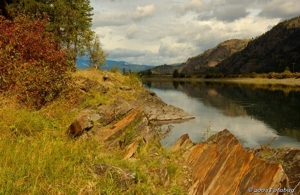
Environmental awareness as well as community commitment has turned the tide on this River. Laws were passed to protect the water quality as well as assure proper sewage disposal. The good news is that the river is and has responded. There has been a return of aquatic insects as well as trout in sections of the Clark Fork.
A pivotal step in the river revival occurred in 1983 when +300 people met to protest a proposal by a local company to dump more waste from its pulp mill into the Clark Fork. The residents (from upstream as well as downstream) were determined not to allow further dumping. This protest and eventual compromise led to the development
of the Clark Fork Coalition which created a forum which many interests (conservationists, elected officials, businesses/industry)meet to openly discuss how to protect the river.
The Clark Fork watershed is designated as a superfund site, with the major sites being Butte, Anaconda and Milltown Dam/Clark Fork River. Huge strides have been made on bringing this river back to life and back to its natural beauty.
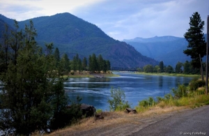
It is once again known for its trout fishing, floating, white water and other recreational activities.
It is also a testament to what can be done when we all work together for a common cause.
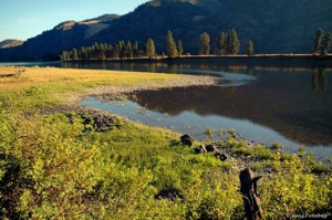
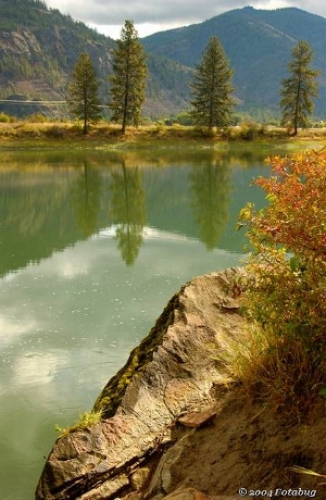
The above photos are courtesy of Vern Rogers . Check out his web site.